West College Street Corridor Historical Survey Public Meeting

Advertisement
The City has engaged Southfield, Michigan-based Loggia Preservation, to conduct an intensive-level historic resource survey of West College from Grant Avenue to Scenic Avenue/Chestnut Expressway starting the week of June 22, culminating with a final report in March 2027.
The survey area falls within the boundaries of the West Central Neighborhood Alliance and the Westside Neighborhood Betterment Association.
The purpose of the survey is to document the architectural and historical significance of individual structures as well as the survey area and to evaluate eligibility for inclusion on the National Register of Historic Places and local landmark designation, said Loggia Preservation’s Cassandra Talley.
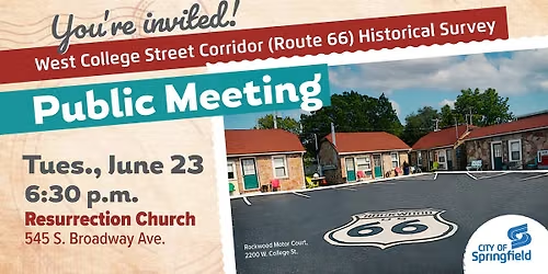
A public meeting is planned for 6:30 p.m. Tuesday, June 23 at Resurrection Church, 545 S. Broadway Ave., to provide details about the survey process and ask residents and business owners to share photos and memories. Once the survey is complete, property owners and the Landmarks Board have the option to seek historic designation individually or as a district.
“Springfield’s Landmarks Board is tasked with identifying and preserving historic resources to benefit the educational, cultural, economic and general welfare of our community,” said Landmarks Board Chair John Hawkins. “Documenting historic structures and corridors, such as Route 66, is an important step in this process. This survey will provide a more thorough and complete inventory of the historic resources which still exist today. It is also the first step in helping guide preservation of any resources which contribute to our city's identity for future generations.”
Currently, the only National Historic Register listing in the area is the Rock Fountain Motor Court at 2400 W. College St., which was added to the register in 2003.
“Following the June 23 meeting, we will be both driving and walking the area to take notes and photos of the structures in the area,” Talley said. “We will be looking at each structure along the route and taking note of materials used in construction to determine if it has historical significance – such as wood vs. siding, aluminum vs. stainless steel on the windows, masonry, etc. We’re also looking at whether a structure has been added on to,” she added.
Talley said her team members always stay in the right-of-way and do not trespass when surveying. She said they are always happy to chat with residents who are curious about the survey or want to share memories of a particular home or structure.
The West College Street study area consists of 181 parcels. The study area has a special connection to Route 66 as it is not only located on the historic route, but it was in Springfield that the name “U.S. 66” was decided upon by a meeting of highway officials in 1926. Statewide surveys of Route 66 were done in 1993 and 2003, but these were assessments of select properties that met specific criteria rather than a survey of every parcel on a specific portion of the Route 66 corridor in Springfield.
Historical surveys are approved by Missouri’s State Historic Preservation Office and must be completed under the supervision of a qualified 36CFR61 historian.
The survey area falls within the boundaries of the West Central Neighborhood Alliance and the Westside Neighborhood Betterment Association.
The purpose of the survey is to document the architectural and historical significance of individual structures as well as the survey area and to evaluate eligibility for inclusion on the National Register of Historic Places and local landmark designation, said Loggia Preservation’s Cassandra Talley.
A public meeting is planned for 6:30 p.m. Tuesday, June 23 at Resurrection Church, 545 S. Broadway Ave., to provide details about the survey process and ask residents and business owners to share photos and memories. Once the survey is complete, property owners and the Landmarks Board have the option to seek historic designation individually or as a district.
“Springfield’s Landmarks Board is tasked with identifying and preserving historic resources to benefit the educational, cultural, economic and general welfare of our community,” said Landmarks Board Chair John Hawkins. “Documenting historic structures and corridors, such as Route 66, is an important step in this process. This survey will provide a more thorough and complete inventory of the historic resources which still exist today. It is also the first step in helping guide preservation of any resources which contribute to our city's identity for future generations.”
Currently, the only National Historic Register listing in the area is the Rock Fountain Motor Court at 2400 W. College St., which was added to the register in 2003.
“Following the June 23 meeting, we will be both driving and walking the area to take notes and photos of the structures in the area,” Talley said. “We will be looking at each structure along the route and taking note of materials used in construction to determine if it has historical significance – such as wood vs. siding, aluminum vs. stainless steel on the windows, masonry, etc. We’re also looking at whether a structure has been added on to,” she added.
Talley said her team members always stay in the right-of-way and do not trespass when surveying. She said they are always happy to chat with residents who are curious about the survey or want to share memories of a particular home or structure.
The West College Street study area consists of 181 parcels. The study area has a special connection to Route 66 as it is not only located on the historic route, but it was in Springfield that the name “U.S. 66” was decided upon by a meeting of highway officials in 1926. Statewide surveys of Route 66 were done in 1993 and 2003, but these were assessments of select properties that met specific criteria rather than a survey of every parcel on a specific portion of the Route 66 corridor in Springfield.
Historical surveys are approved by Missouri’s State Historic Preservation Office and must be completed under the supervision of a qualified 36CFR61 historian.
Advertisement
Where is it happening?
Resurrection Church., 545 S Broadway Ave,Springfield, Missouri, United States
Event Location & Nearby Stays:
Know what’s Happening Next — before everyone else does.
Host or PublisherCity of Springfield, MO