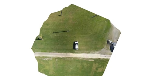
King, NC Mapping

Advertisement
**********Register THROUGH FORSYTH TECH.*************
2D Mapping Basics – Fly a path, capture photos, and create a stitched map for accurate, up-to-date scene overviews.
Operational Uses – Event planning, search & rescue, warrant service, and tactical operations
3D Modeling – Build a “digital twin” of a scene or structure for immersive analysis.
Measurements with Precision – Capture roadway widths, skid marks, distances, and scene details down to the centimeter.
Applications Across Public Safety – Traffic units, CSI, CID, SWAT, fire service, and arson investigations.
Indoor & Outdoor Mapping – Use drones, tablets, or 360 cameras to document and model environments quickly and safely.
Hands-On Training – Expect 1–2 hours of daily flight time plus software processing sessions.
💻 Recommended: Bring a laptop, a drone, and your own Wi-Fi connection (data-heavy!)
2D Mapping Basics – Fly a path, capture photos, and create a stitched map for accurate, up-to-date scene overviews.
Operational Uses – Event planning, search & rescue, warrant service, and tactical operations
3D Modeling – Build a “digital twin” of a scene or structure for immersive analysis.
Measurements with Precision – Capture roadway widths, skid marks, distances, and scene details down to the centimeter.
Applications Across Public Safety – Traffic units, CSI, CID, SWAT, fire service, and arson investigations.
Indoor & Outdoor Mapping – Use drones, tablets, or 360 cameras to document and model environments quickly and safely.
Hands-On Training – Expect 1–2 hours of daily flight time plus software processing sessions.
💻 Recommended: Bring a laptop, a drone, and your own Wi-Fi connection (data-heavy!)
Advertisement
Where is it happening?
Forsyth Tech King Campus, 3111 Big Oaks Dr King, NC,King, North Carolina, United States
Event Location & Nearby Stays:
Know what’s Happening Next — before everyone else does.
Host or PublisherPublic Safety UAS Institute