History of Cartography: Depicting Time and Space (Fall Course)
Schedule
Mon, 22 Sep, 2025 at 06:00 pm to Mon, 17 Nov, 2025 at 07:30 pm
UTC-04:00Location
Parkway Central Library | Philadelphia, PA
About this Event
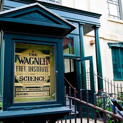
WAGNER FREE INSTITUTE OF SCIENCE – FALL 2025 COURSE: HISTORY OF SCIENCE SERIES
History of Cartography: Depicting Time and Space Professor Darin Hayton
6 Mondays from September 22 - November 3, 2025, from 6 - 7:30 PM
Location: This course meets at the Parkway Central Library, located at 1901 Vine St., Philadelphia
This course requires pre-registration. Separate registration is required for each student. Sign up here or call 215-763-6529 x14 for assistance.
Course Description
Maps are as much about imagined worlds as they are about reality. Rarely are they just a means of getting from one place to another. Instead, they transform our thoughts and uncertainties into something we can see, understand, and control. Over six weeks, this course will look at some important aspects of maps to understand how maps function. By putting them into their specific social and cartographic contexts, the course will examine how they represent and convey ideas about the world we live in.
Course Schedule
1. Monday, September 22, 2025 – Mapping Eden
Throughout the middle ages, Eden regularly turned up on world maps. Although the Bible clearly indicated that Eden existed on earth, it was light on details about where. And despite no traveler reporting having found Eden, cartographers consistently located Paradise in the far east. By the turn of the sixteenth century, however, Eden ceased to appear on world maps, though it continued to be found on regional maps. This class will trace the history of mapping Eden to understand why cartographers finally stopped putting paradise on the map.
2. Monday, September 29, 2025 – Early Maps of Pennsylvania and Philadelphia
William Penn commissioned the mapmaker Thomas Holme to create early maps of Pennsylvania and Philadelphia. His Portrait of the City of Philadelphia and his broader Map of the Improved Part of Pennsylvania reflect changing ideas about town design and layout. They also represent Penn’s effort to market his new colony to potential investors and colonists back in England. This class will analyze these maps to understand what messages Penn and Holme were trying to convey to their English audiences.
3. Monday, October 6, 2025 – Maps of Time and Eras
Although early modern scholars developed new techniques for calculating historical periods, they were slow to create visual representations of time. In the 18th century, however, the field of chronology enjoyed immense visual changes. These changes were not limited to historical timelines, but combined periods with other types of information into amazing maps that combined time, space, religion, culture, and history. This class will trace the developments from pre-modern tables to the elaborate chronological maps of the 18th and 19th centuries.
NO CLASS – October 13, 2025
4. Monday, October 20, 2025 – Boundaries and Boundary Disputes
An important and seemingly essential function of maps is marking out boundaries, delimiting the space that is controlled by one person and off limits to another. This function has a history. Once cartographic boundaries came into existence, those boundaries became the object of dispute, regardless of what might or might not be happening in the real world. This class will look at the history of boundary surveying and disputes, with an eye to the protracted dispute between William Penn and Charles Calvert over the boundary between Pennsylvania and Maryland.
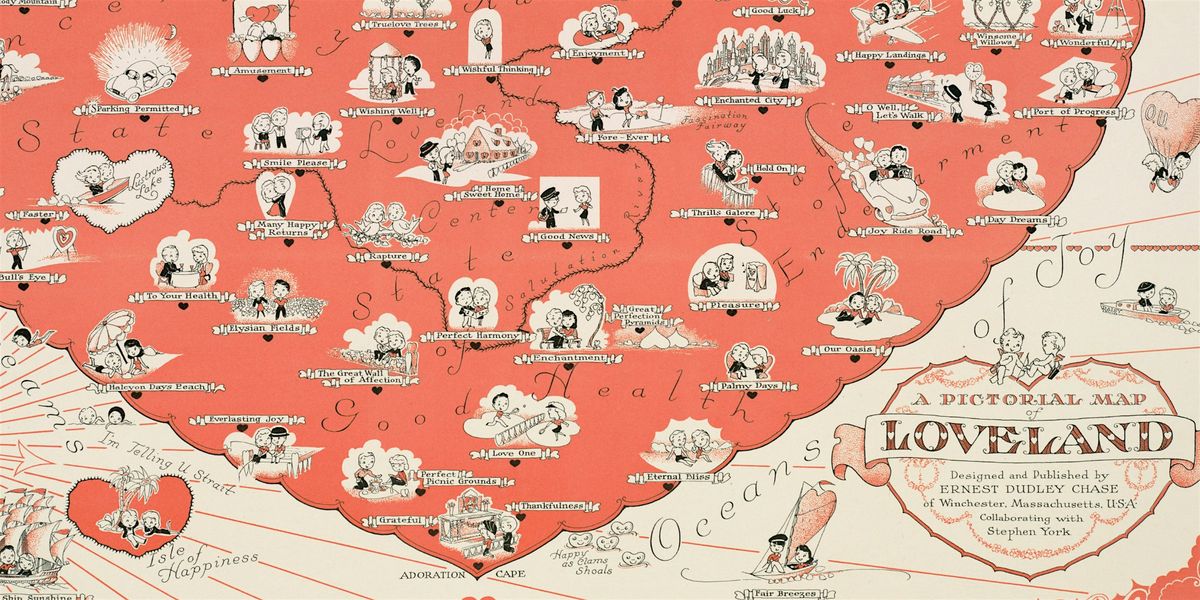
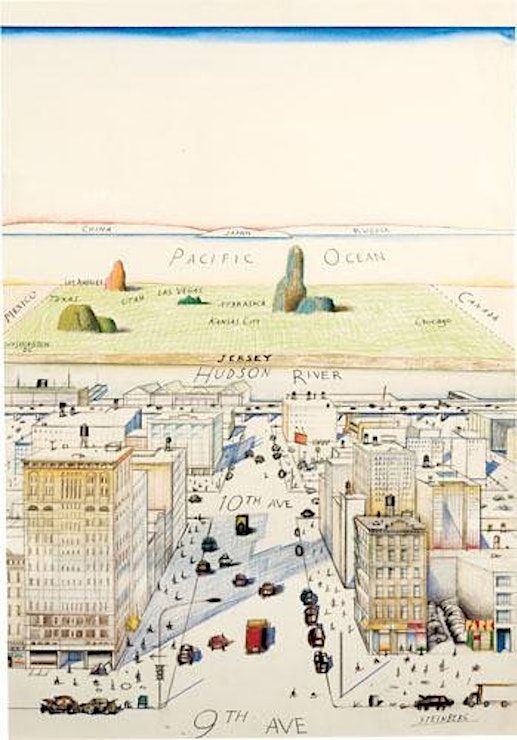
5. Monday, October 27, 2025 – Imaginary Maps
Maps function whether or not the space they purport to map can be traversed by any human. Some of these imaginary spaces are literary, such as Thomas More’s utopia or Dante’s circles of hell, others are conceptual, such as mapping the mind, and others are imaginative distortions of reality. This class will look at a number of imaginary maps to understand how they function as literary and conceptual devices.
6. Monday, November 3, 2025 – Trap Streets and other Cartographic Tricks
Maps are complicated and detailed, and difficult to check against reality. Mapmakers have taken advantage of this aspect of maps to hide all sorts of things in their maps. Most commonly, they have added “trap streets” to protect their maps against plagiarism. This class will look at how trap streets and similar devices have been used by mapmakers to show that their maps have been illegally copied. More amusingly, it will show how such devices have been used as jokes.
Suggested Reading
Selected readings for each week will be available for download online.
The following general histories are recommended:
J.B. Harley, The New Nature of Maps. Essays in the History of Cartography (Baltimore, MD: Johns Hopkins University Press, 2001)
The History of Cartography series is the go to resource. Conveniently, the published volumes are available online:
J.B. Harley and David Woodward (eds.) History of Cartography. Cartography in Prehistoric, Ancient, and Medieval Europe and the Mediterranean, Volume 1 (Chicago: University of Chicago, 1987)
J.B. Harley and David Woodward (eds.) History of Cartography. Cartography in the Traditional Islamic and South Asian Societies. Volume 2, pt. 1 (Chicago: University of Chicago, 1992)
J.B. Harley and David Woodward (eds.) History of Cartography. Cartography in the Traditional East and Southeast Asian Societies. Volume 2, pt. 2 (Chicago: University of Chicago, 1994)
David Woodward and G. Malcolm Lewis (eds.) History of Cartography. Cartography in the Traditional African, Arctic, Australian, and Pacific Societies. Volume 2, pt. 3 (Chicago: University of Chicago, 1998)
David Woodward (ed.) History of Cartography. Cartography in the European Renaissance. Volume 3, pt. 1 (Chicago: University of Chicago, 2007)
David Woodward (ed.) History of Cartography. Cartography in the European Renaissance. Volume 3, pt. 2 (Chicago: University of Chicago, 2007)
Matthew Edney and Mary Sponberg Pedley (eds.) History of Cartography. Cartography in the European Enlightenment. Volume 4 (Chicago: University of Chicago, 2019)
Mark Monmonier (ed.) History of Cartography. Cartography in the Twentieth Century. Volume 6 (Chicago: University of Chicago, 2015)
About the Professor
Dr. Darin Hayton is a historian of science whose research focuses on the creation and dissemination of scientific knowledge, especially the science of the stars (astrology and astronomy) in pre-Modern Europe and the late Byzantine Empire. He is Associate Professor of the history of science in the History Department at Haverford College. He has published a book, The Crown and the Cosmos. Astrology and the Politics of Maximilian I and has just finished a second, a study on astrology in the Byzantine world, which he hopes will be published next year. His interests also reach up into the modern period: he has published an article on the local Friends’ Asylum (“The Inmate’s Window”) and recently has published articles in the online magazine, Distillations, that reveal the echoes of history in modern scientific and legal practices (“Good as Gold” and “Disorderly Persons”). He has taught for the Wagner since 2016.
FAQs
What is the cost?
Wagner courses are free; donations are encouraged!
Are there minimum age requirements to enter the course?
The adult lecture courses are offered on an introductory college level. They are open to anyone seeking an introduction to various areas of science and history of science as well as those familiar with the subjects who wish to broaden and update their knowledge. The courses also provide an excellent opportunity for motivated junior high and high school students to supplement their current science courses and to help prepare them for further study in these fields at a college level. The courses are appropriate as well for teachers seeking to expand their knowledge.
What are my transportation/parking options for getting to and from the course?
The Free Library of Philadelphia Parkway Central Branch is located between 19th and 20th Streets on the Parkway. It is close to many SEPTA lines, including buses, Regional Rail, and the Broad Street Line Race/Vine station. Most parking near the library is metered street parking. There is also a Philadelphia Parking Authority lot behind the library on Callowhill Street between 19th and 20th Streets.
Is the building wheelchair accessible?
Yes. The Wood Street entrance (at the back of the building) is wheelchair accessible and there are elevators in the building. Enter Wood Street by going south on 19th Street and drive west towards 20th Street. If the gate is down press the buzzer and security will open the gate. There are handicapped parking places right next to the building.
How can I contact the organizer with any questions?
Click the "Contact the Organizer" link, email [email protected], or call 215-763-6529 x14.
Images:
Chase, Ernest Dudley. "A pictorial map of loveland." Map. Winchester, Mass: Ernest Dudley Chase, [ca. 1943]. Norman B. Leventhal Map & Education Center, (accessed August 27, 2025).
Thomas Holme, Public domain, via Wikimedia Commons.
Clarence Larkin, The Book of Revelation, 1919.
Saul Steinberg, View of the World from 9th Avenue, Saul Steinberg, 1976.
Where is it happening?
Parkway Central Library, 1901 Vine Street, Philadelphia, United StatesEvent Location & Nearby Stays:
USD 0.00