Donner Summit Canyon -2021
Schedule
Sat Jul 17 2021 at 09:00 am to Tue Aug 10 2021 at 01:00 pm
Location
Donner Summit Canyon Trailhead | Truckee, CA
About this Event
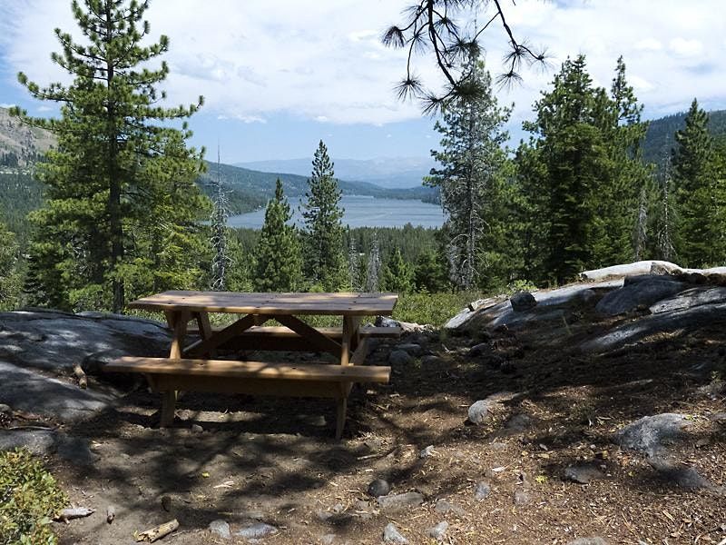
The Truckee Donner Land Trust invites you to hike with us on the trail that loosely follows the original Lincoln Highway route. The route traverses Donner Summit Creek, Donner Peak, and Schallenberger Ridge as it climbs to Donner Summit. You can picnic at the Kathy Polucha Kessler Memorial Picnic Area with an amazing view of Donner Lake. You can marvel at the Native American Petroglyphs as you approach the summit (Please don’t step on them!). You can watch rock climbers near China Wall. You can relax at the lower picnic area. You can count tadpoles in the Beaver Pond.
A trail up the canyon follows much of the old Dutch Flat/Donner Lake Wagon Road, which later served as the Lincoln Highway. Some of the historic features visible from the upper part of the trail include Native American petroglyphs, the China Wall, and the world’s first automobile underpass (1913). Look for the abandoned Turkey Truck that careened off the road in 1955, scattering 30,000 pounds of frozen turkeys down the 175’ drop and delaying Thanksgiving dinner for hungry Nevadans!
Hiking details: Enjoy a docent-led, 6+ mile round-trip hike with a 1,000’ elevation gain; moderately strenuous due to uneven terrain and moderate to steep ascents. Please be out of your vehicle and ready to hike at the time set for the hike to begin.
FAQs
What are my transportation/parking options for getting to and from the event?
From Truckee, proceed West on Donner Pass Road along the North Shore of Donner Lake. As you approach the West end of Donner Lake, go past South Shore Drive and continue up along Old Highway 40 towards Donner Summit. The trail head and parking area is on the left, roughly 1/3 of a mile from South Shore Drive (If you reach the winter closure gate, you have gone too far).
How strenuous is the hike?
This hike is approximately six miles round-trip with a 1,000’ elevation gain; moderately strenuous due to uneven terrain and moderate to steep ascents.
What should I bring to the event?
Please wear closed toe shoes and bring bug spray, sunscreen, water, and snacks you'll need for our outing. Depending on the weather, you may need sun protection (hat/glasses) or rain gear or cold weather gear.
How can I contact the organizer with any questions?
Need to cancel or change your date? Contact [email protected]
Is it ok if the name on my ticket or registration doesn't match the person who attends?
Yes. Tickets are interchangable, but please inform your docent and be willing to fill out the required paperwork at the trailhead. Please make sure that your substitute is aware of the difficulty of the hike.
Are there restrooms available?
No. Please come prepared to use the woods off the trail as necessary.
Can I bring my dog on the hike?
No. Pets will not be allowed on any of the group hikes. We kindly ask that you please leave your pets at home. Your canine companion is welcome at every Land Trust property that is currently open to the public. Please visit tdlandtrust.org for recommendations.
RELEASE and HOLD HARMLESS AGREEMENT
I, the Undersigned, for myself and on behalf of my spouse, heirs, beneficiaries, successors and assigns, acknowledge and agree to all of the following:
In consideration of my participation in Truckee Donner Land Trust trail building, maintenance days, guided tours, docent led hikes and/or volunteer events, I hereby waive, release and discharge any and all claims for damages or injury arising as a result of my participation in these activities, and further agree to defend, indemnify, and hold harmless the Truckee Trails Foundation, Truckee Donner Land Trust, and the U.S. Forest Service on whose property the above activities may occur (collectively “Releasees”), and their respective officers, directors, employees, and agents from and against any loss, liability, damage, causes of action, cost or expense for or on account of bodily injury or property damage arising from or in any way related to my participation in the above activities or as may be related thereto. This Release and Hold Harmless Agreement shall apply regardless of any negligence or carelessness on the part of Releasees.
I acknowledge that there are natural conditions which are or may be inherently dangerous and that I may suffer serious bodily injury or death, or which may cause injury to property. I hereby agree to and assume all risks of harm, including but not limited to property damage, bodily injury, or death, as may result from engagement in the above activities or resulting from the acts, omissions or conduct of Releasees.
I give the Truckee Trails Foundation and Truckee Donner Land Trust permission to use for publicity purposes any photographs or video footage including my likeness that may be taken during the above activities.
I have carefully read this agreement and fully understand its contents. I have freely and voluntarily executed this agreement.
Photo Credit: Anne Chadwick
Where is it happening?
Donner Summit Canyon Trailhead, Trail head is about .3 miles past South Shore Drive along Old Highway 40 towards Donner Summit, Truckee, United StatesEvent Location & Nearby Stays:
USD 0.00